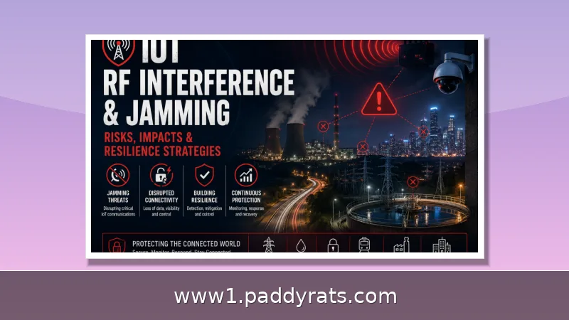
Intentional radio frequency jamming can silence 911 calls, blind GPS-guided medical aircraft, and degrade public safety radio far beyond the jammed zone. A practical jamming impact assessment maps wireless dependencies, tests fallbacks, and documents what breaks before an emergency does.
What Is Jamming and Why Does It Threaten Emergency Service Coverage?
Jamming is what happens when someone deliberately transmits a radio signal with enough power and the right characteristics to keep a receiver from acquiring or tracking information in a given area. In security terms, it's a denial-of-service attack on the air interface: it raises the noise floor or saturates a channel so that legitimate transmissions can't be received reliably. For emergency services, that means timing, telemetry, access, and control signals can all be interrupted at the exact moment responders are counting on them. And it's not a gray area legally—federal law prohibits operating, marketing, or selling jamming equipment that interferes with authorized radio communications, including cellular, PCS, police radar, and GPS. There are no exemptions for business, classroom, residence, or vehicle use.
This isn't just a hypothetical concern. Signal jamming devices can block 911 and other emergency calls, and they put public safety communications at serious risk — which is exactly why the FCC has gone after sellers so aggressively. In May 2016, the agency fined a Chinese electronics manufacturer and online retailer $34,912,500 for marketing 285 models of signal jamming devices to U.S. customers over a span of more than two years. When a jamming incident comes up, I treat it as a coverage problem first and a security problem second, since it's the loss of coverage that ends up delaying the response.
How Does Jamming Disrupt 911 Calls, Public Safety Radio, and GNSS-Dependent Response?
Jamming works by raising the noise floor or saturating a radio channel until legitimate transmissions simply can't get through. The result: a 911 call that never connects, public safety radio traffic that breaks up or drops out entirely, and GPS location data that degrades to the point where dispatchers can't pinpoint a caller or a unit. And the damage doesn't stay neatly contained. Coverage loss can extend well beyond the jammed area, creating service gaps, failed coordination, and safety incidents that on the surface look like unrelated equipment failures. Since GNSS supplies both the location and the timing that emergency services, mobile networks, and critical infrastructure all lean on, a single jammer can ripple outward on two fronts at once—disrupting navigation for medical aircraft while also throwing off the timing that communications depend on.
The mechanism matters when you're trying to diagnose an incident. Interference throws off timing, telemetry, access, or control, and GNSS signals reaching Earth are extremely weak—so even a modest amount of power nearby can overwhelm a receiver. Aviation relies on GNSS for navigation, aircraft tracking, and terrain avoidance, and under radio frequency interference, ADS-B position uncertainty and integrity parameters shift, which can help pinpoint affected regions. With 5G, jamming impact ranges from reduced quality of service to complete denial of service depending on jammer power and proximity, and LTE uplink jamming has been experimentally tested against the air interface.
What Are the Warning Signs of Jamming for EMS Providers and Dispatchers?
Some of the warning signs to watch for are unusual white noise, electronic chirping or tones, dead air, intermittent technical difficulties, no audible click when you key the microphone, and abrupt loss of communications—especially when a unit is sitting still. In my experience, the pattern tells you more than any single symptom. If devices that normally work start failing in clusters, or a coverage hole opens up and then vanishes as a vehicle moves, that points to interference rather than a broken radio. Responders should treat these as reportable events and write down the details while they're still fresh.
Reporting a jammer to the FCC isn't complicated: you can file online or call 1-888-CALL-FCC (1-888-225-5332). Either route works, but the report is only as useful as the details you bring to it. Have the agency name ready, along with the date, time, and duration of the disruption, the location, the mission that was affected, and a plain description of what went wrong. Include the equipment type and model, the environmental conditions at the time, the steps your team already took, and — this one matters — which other devices kept working normally. GPS.gov suggests a sensible order of operations before you file: reach out to the wireless provider and troubleshoot your own gear first, then send the complaint to the FCC. That last item, the unaffected devices, is the one people usually leave out, yet it's often the quickest way to tell deliberate jamming apart from an ordinary hardware failure. If a radio dies while nearby devices on the same or similar frequencies hum along just fine, the pattern suggests the problem isn't a broken unit — it's something external interfering with the signal.
How Do You Assess Exposure by Mapping Wireless Dependencies and Testing Fallbacks?
A solid assessment starts with mapping every asset that relies on GPS, Bluetooth, Wi-Fi, or cellular to carry out core functions — and then actually testing what happens when those links disappear. I'd begin with the workflows that touch life safety first: dispatch, location reporting, identity verification, and control of doors, pumps, or vehicles. From there, I'd check whether identity and control workflows have wired, cached, or locally enforceable fallbacks in place. The goal here is to separate real controls from wishful thinking. A dependency you've never tested is an assumption, not a control, and under jamming conditions that gap can show up at the worst possible moment.
When I'm scoping an assessment, the table below is what I reach for first. It lines up the symptom, the likely cause, and the fallback side by side, so a duty officer can take action without waiting on a full incident review.
What Symptoms and Fallbacks Should a Jamming Impact Assessment Capture?
| Symptom | Likely cause | Fallback to verify |
|---|---|---|
| 911 calls fail in good-coverage areas | Cellular jamming or channel saturation | Landline, satellite, or alternate dispatch channel |
| Dead air and no mic click | Uplink jamming on public safety radio | Alternate frequency, relay, or courier messaging |
| GPS position jumps or drops | GNSS interference or spoofing | Inertial navigation, DME, visual navigation |
| Clustered device failures | Localized jammer near a site | Wired links and cached credentials |
| Packet loss and link flaps | Elevated noise floor | Local fail-safe mode and graceful degradation |
Most teams get the biggest payoff from the review step that follows the table. When you go back over an incident, check whether the outage was covering for something else—a jammed window can hide unauthorized access or units that went missing. Frameworks like NIST SP 800-53 Rev. 5 and NIST CSF 2.0 are useful here: they lay out availability and contingency controls and give you wording for redundancy and alternate administrative channels that procurement teams can actually work with. The goal isn't perfect prevention anyway. Resilience controls lean toward redundancy, local fail-safe modes, graceful degradation, and alternate administrative channels, and that's usually the more realistic path.
What Documented Impacts Exist in Aviation, Medical Evacuation, and Economic Estimates?
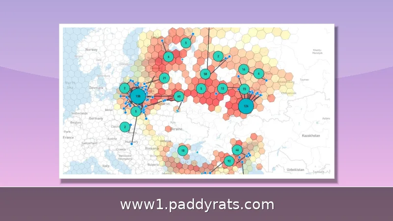
GNSS radio frequency interference has climbed sharply over the past few years, and the pattern is no longer confined to a few hotspots. Civil aircraft often absorb collateral impact from interference tied to conflict zones, and those effects can reach far beyond the disrupted area itself—a flight crew hundreds of miles from the source may still see navigation degrade. A study drawing on crowd-sourced surveillance data from February to December 2022, covering the Baltic states, eastern Europe along the Black Sea, and the eastern Mediterranean, captured that spread. It found impacts ranging from isolated events to regular large-scale recurrent disruptions. That range is the key finding: some regions see occasional glitches, while others face recurring outages that reshape operations—forcing crews and dispatchers to plan around them rather than treat them as one-offs. Put simply, the same technology produces very different operational burdens depending on where you fly or respond, and the trend line suggests more agencies will meet the severe end of that spectrum.
The human toll is documented as well. A medical evacuation aircraft crashed near Ruidoso, New Mexico, on May 14 while the U.S. military was running high-powered GPS denial exercises at White Sands Missile Range. According to the NTSB preliminary report, the crew experienced an abrupt loss of GPS capability; the aircraft struck a 9,950-foot ridge in the Capitan Mountains shortly after midnight, and all four occupants were killed. No probable cause has been declared, so the investigation remains open, but the timing and the loss of signal are hard to separate. On the economic side, a UK study estimated that a loss of GNSS would cost emergency and justice services £1.5bn — 30% of all estimated costs. That share is striking: it shows how concentrated the damage falls on services that cannot simply pause and resume once the signal comes back.
Which Resilience Controls and Alternatives Reduce Jamming Risk?
Aviation is less dependent on GNSS than some industries because of multilayered safety and alternative means such as DME and onboard inertial navigation, though accuracy may be limited compared with modern satellite systems. The UK maintains over 50 DME beacons as a GNSS-independent navigation means, and the first GNSS receiver was certified in 1994, so the backup layer has decades of operational history behind it. For ground services, the equivalent is a documented alternate channel and a rehearsed procedure, not a spare device in a closet.
Detection technology is getting better, but it still varies a lot depending on what you're trying to sense and where. GNSS-RO satellites measure how signals bend through the atmosphere, and during deep occultation they can pick up an anomalous boost in signal amplitude that may point to an interference source. That gives you global-scale reach, though the method is still emerging and largely underused. RF fingerprinting sits at the other end of the spectrum: it needs specialized gear like high-gain antennas and tends to work only in localized or receiver-based settings. For satellite monitoring, GEO on-orbit jamming detection pairs random forest with PCA to catch stationary jamming and adaptive thresholding to handle time-variant cases; related satellite jamming research goes further, testing 5,000 different attacker positions to gauge spatial coverage. On the commercial side, tools like JamAlert by ESI detect cellular frequency jamming—a handy tripwire for dispatch centers, even if it won't catch every threat vector. The upshot is that no single method covers everything, so stacking global, localized, and commercial detection gives you the most practical picture.
How Should Agencies Prepare Before the Next Jamming Incident?
Preparation is mostly administrative discipline backed by testing. Map every asset that depends on GPS, Bluetooth, Wi-Fi, or cellular for a core function, then run a tabletop where those links vanish. Confirm that identity and control workflows have wired, cached, or locally enforceable fallback, and that dispatchers know the FCC reporting details without looking them up. Coordinate with DHS Science and Technology Directorate guidance, CISA SAFECOM-NCSWIC resources, and FAA and GPS.gov advisories so your local plan matches national expectations.
Finally, keep the reporting habit alive after the incident. Document duration, location, affected mission, and unaffected devices, and feed the results into the next assessment cycle. Organizations active in this space include the GPS Innovation Alliance, ECAC, the UK Civil Aviation Authority, ZHAW, ONERA, Polytechnique Montréal, Cornell University, PlanetiQ, Ericsson, and UNHCR/WFP Joint Assessment Missions. Their published work is where I look first when a new interference pattern appears, because the assessment only improves when field reports and research meet.
Frequently Asked Questions
How does jamming affect emergency service coverage?
Jamming raises the noise floor or saturates a radio channel, blocking legitimate transmissions. This can prevent 911 calls, disrupt public safety radio and GPS-based location, and delay response. Coverage loss may extend beyond the jammed area and can cause service loss, failed coordination, and safety incidents.
What are the warning signs that emergency communications are being jammed?
Warning signs include unusual white noise, electronic chirping or tones, dead air, intermittent technical difficulties, no audible click when keying a microphone, and abrupt loss of communications, especially when stationary. Responders should report suspected jamming to the FCC with date, time, location, and affected operations.
Why is GNSS jamming a risk to emergency services?
GNSS provides location and timing data used by emergency services, mobile networks, and critical infrastructure. Jamming can degrade navigation for medical aircraft and disrupt timing for communications, and effects can extend far beyond conflict zones. A UK study estimated emergency and justice service losses at £1.5bn, 30% of total GNSS disruption costs.
How is jamming impact assessed for emergency coverage?
Assessment maps which assets rely on wireless links for core functions, tests what happens when those links fail, and reviews symptoms such as packet loss, link flaps, and clustered device failures. Post-event reviews check whether the outage masked other activity. Frameworks such as NIST SP 800-53 Rev 5 and NIST CSF 2.0 guide availability and contingency controls.